


Monitoring Greater Houston from space:
two decades of dramatic land cover change
The Houston-Galveston metropolitan area has experienced extraordinary growth over the past two decades. While census data provides a unique insight into the nature of that growth, its sparse temporal frequency limits its application for assessing fine-grained change. This study takes a different approach to quantifying how the greater Houston area is changing, agnostic to ground sampled data on development and population growth. Instead, this research leverages over twenty years of satellite observation to synoptically characterize the spatio-temporal dynamics of land cover change on an annual basis from 1997-2017. Driven by a demand for spatio-temporal accuracy and consistency, we employ 262 Landsat images across three space-borne observation platforms to classify land cover change using a three-part algorithmic procedure: automated training data selection of NLCD cover using Automatic Adaptive Signature Generalization (AASG), random forests image classification, and a series of spatio-temporal filters, which allow for an annual, spectrally-based classification of the NLCD’s Developed - Open class, otherwise classified using non-spectral, decadal, ancillary data. The classification time series is validated using accuracy comparison with NLCD products from 2001, 2006, and 2011, as well as independent high resolution satellite data from Ikonos, Quickbird, and Worldview sensors. Results include detailed change maps, conversion time series, uncertainty maps, and a categorization of urbanization morphologies in the Houston area. In addition to its methodological innovations in the field of remote sensing, these results confirm that extraordinary scale of urbanization in Houston, especially in floodplains and ecologically sensitive areas.

Fig 1. Landsat OLI satellite imagery and the 35,000km2 Houston-Galveston study area (black and red).

Fig 2. Semi-transparent classification layer superimposed on high resolution imagery

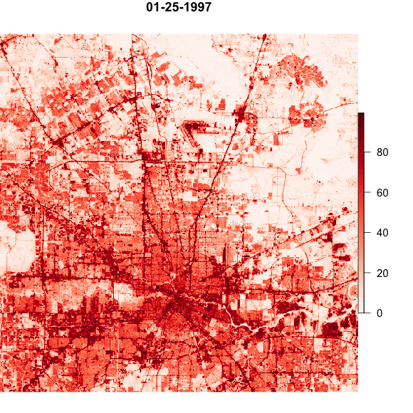
Fig 3. Landsat imagery and classification detail
See the piece in Kinder's The Urban Edge and a video presentation from the 2018 Rice Data Science Conference
Data available on the Kinder Institute's Urban Data Platform and the rG project page.

Fig 4. Land conversion change dates from violet (~1997) through red/brown (~2017)
Houston Subannual Percent Impervious (SPI) Land Cover Dataset: 1997-2018


Subsequent work has focused on the characterization of even fine temporal and thematic resolution land surface dynamics in Houston, TX. The Houston SPI data product represents a significant step in this direction, featuring predicted impervious fractional cover values from 0-100% (rather than four discrete classes) and sub annual temporal resolution over a 22-year temporal extent.
The Houston SPI was produced while developing the automatic adaptive signature generalization and regression (AASGr) algorithm. Provided a robust reference map corresponding to the date of one image, AASGr automates the prediction of continuous fields maps from imagery time series that is adaptive to the spectral and radio- metric characteristics of each target image and thereby requires neither atmospheric correction nor data normalization. The Houston SPI map time series achieved high accuracy in a three-part validation procedure and reveals spatio-temporal dynamics of urban intensification and extensification at a level of detail previously elusive in discrete classifications or coarse temporal-resolution map products.
The Houston SPI is significant in that it showcases the utility of AASGr to quantify subannual land cover dynamics and subpixel heterogeneity (Fig. 5). AASGr-enabled time series are capable of simultaneously characterizing both urban extensification (conversion of pervious to impervious surface) and intensification (changing intensity of fractional impervious cover in any one pixel) — a feat otherwise unattainable with hard classifiers. This level of precision is noteworthy for the next-generation urban land cover change applications requiring precise characterizations of land cover change morphologies along a continuum of spatio-temporal change. Land cover time series that is near continuous in space and time offers several advantages to coarse spatial resolution, temporally-sparse time series by more precisely capturing heterogeneity in spatially complex areas, thereby better lending themselves to the derivation of indices of continuous surface metrology.
The Houston SPI data product supports ongoing interdisciplinary analyses on topics such as socio-economics and demography, development and conservation, flood hazards and planning, urban hydrology and is freely available on the Kinder UDP website at the green link above. The AASGr algorithm description, as published in IEEE Geoscience and Remote Sensing Letters, is available here.
Fig. 5. Continuous change in impervious cover for three dates in Houston, TX. Intermediate colors represent overlap between dates.